|
| From Bruce Beyaert:
Check out the excellent SF Chronicle article below featuring the 30th Anniversary of the San Francisco Bay Trail.
Re the statement "Richmond —the Bay Area city with the most shoreline — has 35 miles of Bay Trail, not all contiguous”, all 35 miles will be contiguous when the Goodrick Ave. Bay Trail section is completed. In fact, when the Bay Trail sections are completed at Goodrick Ave. and Golden Gate Fields, the Bay Trail will be continuous between Pt. Pinole Regional Shoreline and Yerba Buena Island! TRAC hopes that construction will start soon on the long-delayed Goodrick Ave. Bay Trail Project, so that it will be able to share in the publicity surrounding opening the trail between Buchanan and Gilman Streets.
It's disappointing that the Chronicle author didn’t include Richmond in the statement “Among the longest stretches are 25-mile trails in Santa Clara County from East Palo Alto to San Jose and in San Mateo County between Millbrae and San Carlos”. Richmond has more than 25 continuous miles between the Richmond Parkway at Goodrick and the Albany border if Class III sections are included, e.g. bike lanes and sidewalks on inland stretches such as Cutting Blvd. and Harbour Way South.
Speaking of anniversaries, TRAC celebrates its 20th Anniversary this month.
Bruce
https://www.sfchronicle.com/bayarea/article/At-30-the-San-Francisco-Bay-Trail-continues-to-14071844.php
At 30, the San Francisco Bay Trail continues to grow
Local // Bay Area & State
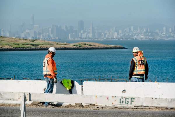
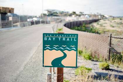
1 of 3 Spectacular views of the bay and San Francisco will be a feature of a new segment of the Bay Trail between the Albany Bulb and the foot of Gilman Street.Photo: Michael Short / Special to The Chronicle
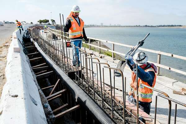
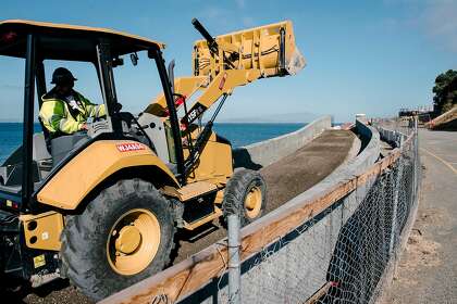
2 of 3 A Gordon N. Ball In. crew works on a new section of the Bay Trail along the shore of the bay adjacent to Golden Gate Fields.Photo: Michael Short / Special to The Chronicle
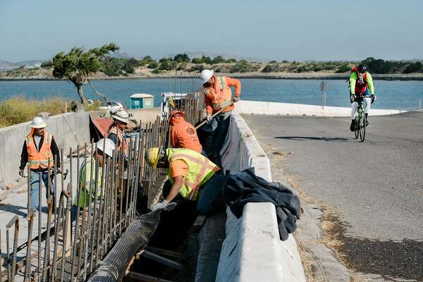
3 of 3 A cyclist passes by workers with contractor Gordon N. Ball who are building a new section of the Bay Trail near Golden Gate Fields. Photo: Michael Short / Special to The Chronicle
Horse racing may be between seasons at Golden Gate Fields in Albany, but there’s plenty of action just west of the grandstand on a bluff with a stunning view of the Golden Gate Bridge and San Francisco Bay.
Bicyclists and pedestrians will have access to that view by the end of the year when it becomes the newest stretch of the San Francisco Bay Trail, a path that one day will circle and cross the bay over 500 connected miles. The trail — with 356 miles completed so far — celebrates its 30th anniversary this month.
All nine Bay Area counties and 47 cities are included in plans for the trail and all have agreed to help it encircle the bay. The purpose of the trail is to bring Bay Area residents closer to the bay while creating recreational opportunities as well as corridors for those who commute on foot or bike, said Laura Thompson, who manages the Bay Trail project for the Metropolitan Transportation Commission and the Association of Bay Area Governments.
“An important part of the Bay Trail is that it’s for everyone, for people of all ages and abilities all around the bay,” she said. “It takes people through a number of environments and lets people enjoy it in their own way.”
In Albany, construction crews have carved a shelf in the cliff near Fleming Point and are pouring concrete along a roughly mile-long extension that fills a gap in the Bay Trail. The new path connects a small beach near the Albany Bulb and the foot of Gilman Street in Berkeley across 4.8 acres donated by Golden Gate Fields in 2016. The $8 million project is expected to open in December.
Intrepid trail users can already close the gap, but it requires braving the Golden Gate Fields parking lots and battling traffic, rough pavement and steep grades. The experience isn’t relaxing, pleasant or family friendly.
“That will be no longer,” Thompson said. “We will have a dedicated trail for cyclists and pedestrians. There are going to be spectacular views. When you’re out there, you can see all across the bay, downtown San Francisco, Mount Tam.”
While the Albany project is just 1/500th of the Bay Trail, it’s a good example of how the trail has been assembled over the past three decades — and the challenges it faces as it presses forward.
“It illustrates how the Bay Trail comes together piece by piece,” Thompson said.
The idea to piece together a trail around the bay was born at a lunch between then-Assemblyman Bill Lockyer, of Hayward, and the editor of the now-defunct Hayward Review in 1986. After Lockyer complained about a story critical of some legislation he authored, he floated the trail idea.
In 1987, Lockyer, backed by the entire Bay Area legislative delegation, got legislation passed creating the Bay Trail. In 1989, the official map for the 500-mile trail, which also includes paths across seven toll bridges and various spurs to nearby parks and places of interest, was completed.
The longtime East Bay lawmaker counts the Bay Trail among his greatest accomplishments.
“There’s been a lot of progress,” said Lockyer, now an attorney at an Orange County law firm. “It’s been sort of incrementally completed. Some counties have been extraordinary and there are some places that are difficult to complete. But they keep working at it and that’s good.”
The Bay Trail has taken shape in piecemeal fashion — a mile here, 6 miles there — at various locations around bay. Among the longest stretches are 25-mile trails in Santa Clara County from East Palo Alto to San Jose and in San Mateo County between Millbrae and San Carlos.
An East Bay stretch connects 17 miles though San Leandro and Hayward. Richmond — the Bay Area city with the most shoreline — has 35 miles of Bay Trail, not all contiguous.
A recently completed piece in Pinole, where a curving concrete bridge swoops over wetlands and railroad tracks from a shoreline park to a nearby bluff, is among the most dramatic stretches — and was one of the most technically difficult to complete.
“It was an engineering answer to a complex landscape,” Thompson said. “It was not so easy as laying asphalt in some areas.”
Regardless of its location, the Bay Trail is popular. On weekends and sunny afternoons, many stretches are crowded with joggers, bicyclists and dog walkers. Weekdays bring fewer visitors but they enjoy the solitude — and the views.
“I use it all the time,” said Dmitrius Rodriguez, a 20-year-old Contra Costa College student and barista from San Pablo, who grew up in Hayward. “You can get a little workout in, do some people-watching and look at the bay without going far.”
Rodriguez was hiking through the Golden Gate Fields parking lot, breaking in his backpacking gear — and himself — for a summer trek in Yosemite National Park. After a test at Contra Costa College, he drove to Point Richmond, started hiking and planned to go to Emeryville.
“It’s pretty awesome,” he said as watched construction crews working on the new stretch of trail. “I’m glad they’re putting money into something like this that people like and will use.”
He’s used sections of the Bay Trail all his life, mostly in Hayward and now in the upper East Bay, but said he had no idea it covered more than 350 miles.
Some trail users admit they’re only familiar with the stretches close to their homes and weren’t aware the trail may someday circle the bay. But that doesn’t stop them from appreciating the path, which is generally paved and at least 8 feet wide, often with dirt or gravel paths alongside. Benches, drinking fountains and restrooms appear intermittently.
“It’s beautiful up here,” said Judith Holten-Mendez 78, a retired dance teacher from Richmond, as she walked her blind dog along the trail on grassy bluffs in Pinole. “I said to myself, ‘Why are you walking the dog in the neighborhood? Get out and see the beauty that God created.’”
Since they retired from Safeway five years ago, Rebecca Ritchie, 60, and Tony Peovich, 62, walk the trail regularly at both Point Isabel in Richmond and in Pinole.
“We love it,” she said. “We never had time to do it before. Now we’re taking advantage of it.”
It is difficult to place a price tag on the Bay Trail, Thompson said, since different segments are built by different entities and nobody kept track in the early days, “but it is in the realm of hundreds of millions of dollars,” she said.
The money to build the trail comes mostly from local parks and recreation taxes, state bond measures and grants, regional transportation measures and some federal transportation funding. Developers building along the bay are often required to install part of the trail, and some property owners donate land.
Planners believe it will cost another $1.4 billion to complete the trail, but when it will be done is a tougher question to answer. With less than a third of the trail left to build, Thompson said, “You’d think we could say we’re in the homestretch. But a lot of what’s left is more difficult.”
That includes the least-developed stretch of the trail along the northern edge of the bay paralleling Highway 37. Other crucial stretches include the San Francisco shoreline near the former Hunters Point shipyard and parts of western Contra Costa County along San Pablo Bay, said Thompson and Sean Dougan, trails development program manager for the East Bay Regional Parks District, which has built 40 miles of the Bay Trail in its parks and has 47 miles to go.
Thompson said the Bay Trail should be “substantially completed” in the next decade. Planners and trail backers intend to keep the momentum.
“We have to do it sooner,” said Dougan, “because it gets more and more expensive the longer we wait.”
Michael Cabanatuan is a San Francisco Chronicle staff writer. Email: mcabanatuan@sfchronicle.com Twitter: @ctua
|