|
| This responds to David Helvarg’s April 16 Open Forum posting, “Unanswered Questions at Point Molate” (see below this E-FORUM):
There really are no unanswered questions about Point Molate, studied to death since 1995 with hundreds of public meetings, dozens of consultants’ reports and two certified EIRs.
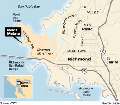
In a process begun 24 years ago, Point Molate was transferred from the Navy to the City of Richmond for economic development, not for abandonment. It includes the substantially intact infrastructure of what 100 years ago was the largest winery complex in the world, now the Winehaven Historic District, listed on the National Register of Historic Places.
Helvarg, and the small, self-appointed, Point Molate opposition group he associates with, have about as much respect for facts as Donald Trump and have no qualms about making up whatever supports their opposition to development of Point Molate.
For example, Helvarg describes the future Point Molate as “Buttville,” with “5,000 to 10,000 people and several thousand cars.” This is pure fabrication. The residential community under consideration ranges from 670 to 1,100 units. Using Contra Costa’s average household size of 2.81, this is 1,883 to 3,009 people, not 5,000 to 10,000, and likely significantly fewer because of the residential unit sizes and densities.
Helvarg cites the proximity to Chevron as reason enough not to develop Point Molate. Upwind from Chevron and separated by a 400-ft. high ridge, Point Molate is one of the safest and most seismically stable places in Richmond. In nearly 120 years, there has never been an incident at Chevron that caused evacuation of Point Molate or the Point San Pablo peninsula. The 2012 Chevron fire that Helvarg describes sent a smoke plume over Richmond and West County in the opposite direction of Point Molate. The flaring incidents of 2018 referred to by Helvarg were all Level 1, meaning no off-site consequences.
Helvarg continues to assert that development will degrade runoff water from the site and destroy the “eelgrass beds and their fish and Dungeness Crab nurseries.” The EIR states just the opposite, concluding that with “the implementation of the full suite of habitat restoration, on-site biological mitigation, and improvements to the aged stormwater system currently in place, the quality of water discharged to the Bay is expected to significantly increase.”
Helvarg asks, “When will Point Molate’s unique habitats be called out for protection in an Environmental Impact report?” In fact, they were, and all will be reduced to a less-than-significant level with recommended mitigations. For Alternative D, the latest EIR states, “Implementation of Mitigation Measures 4-1 through 4-9 would reduce impacts to annual grassland, coastal scrub, and mixed riparian habitats to less-than-significant levels; Implementation of Mitigation Measures 4-10 through 4-12 would reduce impacts to wetlands and waters of the U.S. to a less-than significant level; Development of Alternative D would result in less-than-significant impacts to navigable waters within the project site, as such, fisheries resources would not be impacted;” and “Implementation of Mitigation Measures 4-15 through 4-18 would reduce impacts to nesting bird species to a less-than-significant level.”
Like Treasure Island, which is planned to house over 8,000 future residents, Point Molate has one access road that can easily handle the projected traffic. It also has a new Bay Trail connection that provides access to pedestrians and bicyclists, and there are multiple potential access points for future ferry service. Helvarg is obsessed with evacuation, but Point Molate is no Town of Paradise. It is not surrounded by forests, and along with the rest of the Point San Pablo peninsula, fronts four miles of San Francisco Bay.
In April of 2018, the Richmond City Council entered into a settlement agreement in Federal Court to end years of litigation involving Point Molate. The agreement, entered as an order by the Court, provided for implementation of a Reuse Plan that was originally adopted by a 45-member advisory committee and City Council in 1997. The plan, which included residential development, was the subject of CEQA review in both 1997 and again in 2011.
The Reuse Plan anticipated housing as part of a mixed-use complete 24/7 community that included rehabilitation of buildings in the Winehaven Historic District for commercial uses, a variety of recreational uses with a waterfront park, and housing. Approximately 70% of the site will be open space, and 30% will be developed. The developed areas are limited to sites previously built on or disturbed by previous industrial uses.
We need to cease letting the obstructionists control the Point Molate agenda with made up facts and move ahead.
Tom Butt
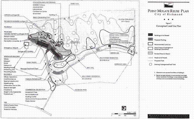
Figure 1 - 1997 Reuse Plan from the 1997 EIR
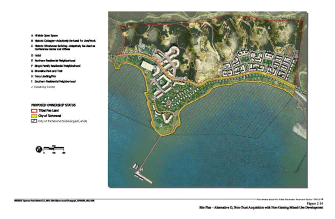
Figure 2 - 2011 EIR Alternative D - Mixed Use, loosely based on the 1997 Reuse Plan
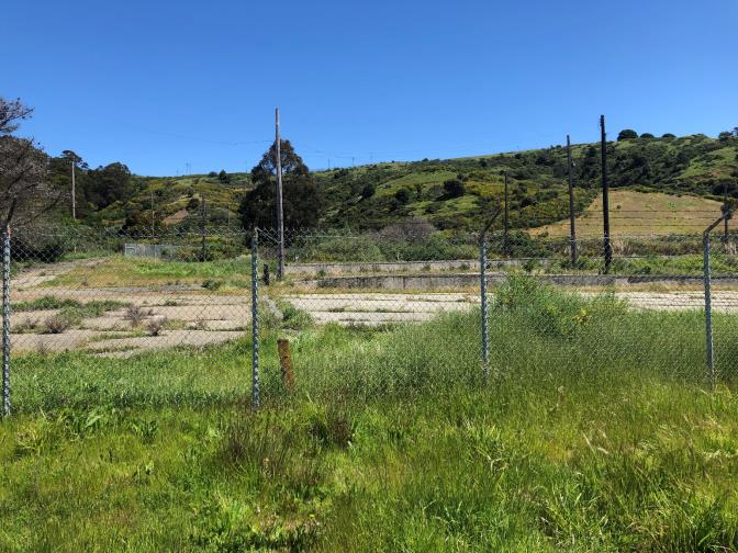
Figure 3 - The area known technically as "Drum Lot 2" and euphemistically referred to by Helvarg as the "south watershed" is a probable site for housing. It is not a pristine habitat for native plants. It is a former Brownfield site, cleaned up for residential uses, heavily graded and still with extensive concrete paving. The chaparral visible in the background is largely invasive exotic species including French Broom, Pampas Grass and Fennel. Blue Gum Eucalyptus is another invasive exotic species that dominates the Point Molate woodlands. Development would provide substantial resources to remove and restore the ecologically degraded Point Molate uplands.
SF Chronicle Opinion // Open Forum
https://www.sfchronicle.com/opinion/openforum/article/Open-Forum-Unanswered-questions-at-Point-Molate-13767464.php
Open Forum: Unanswered questions at Point Molate
By David Helvarg April 16, 2019 Updated: April 16, 2019 9:41 a.m.
Comments
Question: Where would you want to build a luxury-housing tract if you were the mayor of Richmond?
Answer: On an isolated natural headland between a crowded bridge and an accident-prone oil refinery.isolated natural headland between a crowded bridge and an accident-prone oil refinery.

The Chevron refinery in Richmond is near the site being proposed for an upscale neighborhood. Will high-income families be willing to live near the refinery?
Photo: Michael Macor / The Chronicle 2017
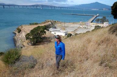
Pam Stello, with the Citizens for a Sustainable Point Molate group, walks on a bluff with the Richmond-San Rafael Bridge in view above Point Molate, where a developer hopes to build residential homes, in Richmond. Residents and environmentalists are not happy with a plan by the city’s mayor to hand over prime real estate to the developer.
Photo: Paul Chinn / The Chronicle 2016
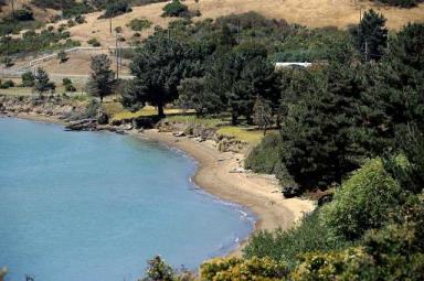
Point Molate Beach Park, which was closed from 2003 to 2014, connects key portions of the Bay Trail between the Port of Richmond, Point Richmond, Point San Pablo and Point Pinole.
Photo: Michael Short / Special to the Chronicle 2012

The old warehouse in the Winehaven district served as a winery — the world’s largest at the beginning of the 20th century — predated the Navy’s arrival at Point Molate in Richmond.
Photo: Michael Macor / The Chronicle 2016
If Richmond’s latest plan for the long fight over the public lands and waters of Point Molate seems odd, Mayor Tom Butt will tell you this is no time for debate. He’s pushing to keep to a timeline designed to expedite a bad legal settlement he agreed to last year that is being challenged in federal court. The city is now looking to sell Point Molate to a major Southern California real estate corporation — SunCal — that was recently chased out of Alameda.
But there is another timeline the mayor and his supporters do not want people looking at: the traffic and air quality concerns timeline.
On Feb. 7, the Richmond-San Rafael Bridge was partially closed after an 8-inch chunk of concrete roadway fell on a motorist’s car, backing up traffic into Richmond and beyond.
The Chevron refinery in Richmond is near the site being proposed for an upscale neighborhood. Will high-income families be willing to live near the refinery?
Photo: Michael Macor / The Chronicle 2017
A month later, Chevron issued a warning about a March 6 flaring incident at its Richmond oil refinery.
On March 17, a plume of black smoke had floated over the Point Molate headland as Chevron issued a community warning. “People get freaked out about it, and the answers they are getting are becoming less and less credible,” the mayor complained to the
East Bay Times.
Two days later, on March 19, in a closed-to-the-public session, the mayor and the Richmond City Council voted to accept Irvine-based SunCal’s bare-bones proposal to build expensive housing at Point Molate. Has it been mentioned Point Molate is publicly accessible only by a narrow two-lane road that lets out at the eastern toll plaza of the bridge?
Pam Stello, with the Citizens for a Sustainable Point Molate group, walks on a bluff with the Richmond-San Rafael Bridge in view above Point Molate, where a developer hopes to build residential homes, in Richmond. Residents and environmentalists are not happy with a plan by the city’s mayor to hand over prime real estate to the developer.
Photo: Paul Chinn / The Chronicle 2016
On April 5, 17 days after the City Council’s vote, the bridge shut down again after a chunk of concrete fell off it — the second time in two months. Bridge traffic has increased 13 percent since 2013. But with a new “community” (“Buttville,” perhaps?) of 5,000 to 10,000 people and several thousand cars being developed next to the bridge, rush-hour traffic — not to mention evacuation in case of an emergency — could become an even bigger nightmare.
In August 2012, there was a major fire at Richmond’s 117-year-old Chevron refinery located just over Point Molate’s ridgeline. It sent more than 14,000 people to area hospitals complaining of burning eyes, nausea and respiratory problems. In 2018, there were eight flaring incidents at the refinery — the most to occur in a single year in more than a decade, according to the regional air quality regulator. That number might be surpassed by this year’s repeated unplanned releases — five to date.
Point Molate is rated as a “Very High Fire Severity Zone” on City of Richmond fire maps.
Along with citizen groups such as the Point Molate Alliance, which is concerned with the environmental, safety, economic and equity risks associated with the planned housing tract, Chevron can’t be too thrilled with the idea of a new refinery fence line community made up of wealthy people who have lawyers.
Before the city moves ahead with selling off Point Molate for development, it really needs to answer unresolved questions — questions that require real consideration and open debate — none of which has happened to date:
What is the evacuation plan in case of a major wildfire, refinery explosion or earthquake?
What are the traffic and safety issues? When will we have an Environmental Impact Report?
When will Point Molate’s unique habitats be called out for protection in an Environmental Impact Report, including the San Francisco Bay’s most intact eelgrass beds and their fish and Dungeness crab nurseries?
What will the annual property tax benefit be, if any (if the city backs an expected bond for infrastructure, it may not see any additional revenue for 40 years or more)?
What will fire and police protection and other city services cost annually for a new neighborhood?
Will high-income families want to spend a $1 million or more each to live there?
What’s the city’s worst-case financial risk from this development?
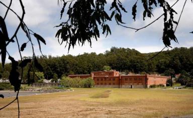
The old warehouse in the Winehaven district served as a winery — the world’s largest at the beginning of the 20th century — predated the Navy’s arrival at Point Molate in Richmond.
Photo: Michael Macor / The Chronicle 2016
Point Molate could be a world-class public park, with recreational, cultural and commercial jobs and opportunities based around its historic Winehaven district. Or it could be an isolated, upscale private-housing tract.
Neither option should be pursued however before we have definitive answers to these unanswered questions.
David Helvarg is a Richmond author, executive director of Blue Frontier, an ocean conservation organization, and co-chair of the Point Molate Alliance.
|