|
|
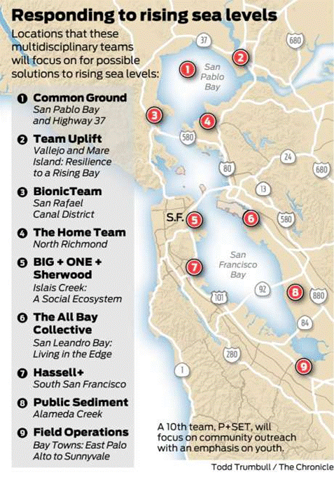
“The Home Team” is assigned to the North Richmond Shoreline.
So far, local politicians seem comfortable with the idea that teams of architects and planners and engineers — some from outside the region, others from out of town — will be offering elaborate suggestions on what shape the local communities’ futures might take.
“Having the opportunity for a world-class team to look at our shoreline, that’s not something we would want to pass up,” said Richmond Mayor Tom Butt.
Butt is on Resilient by Design’s executive board. Richmond was selected as one of the sites even though it passed its own adaptation plan in 2016.
“They might bring us something out of the box,” Butt explained. “Something we haven’t thought of before.”

Design competition tackles sites around Bay Area to address rising waters
By John King, January 11, 2018
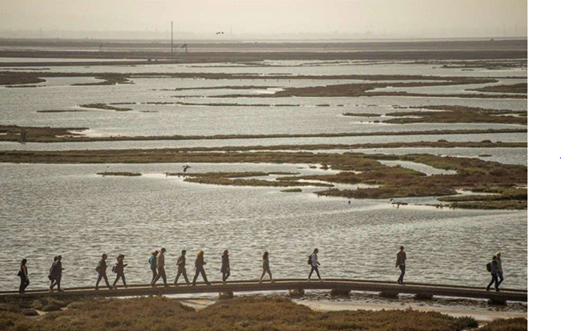
Members of the design teams in Resilient By Design's Bay Area Challenge during a fall visit to the Don Edwards San Francisco Bay National Wildlife Refuge.
Channelized creeks opened up so that sediment can spill into the bay and bring marshes back to life. Landscaped waterways lined by high-rise housing. Floating buildings grouped inside new lagoons along the shore.
These visions, of a region where cities and nature are entwined more closely than ever before, aren’t the work of idle dreamers. They’re responses to the likelihood that sea level rise in coming decades will transform the body of water that gives the Bay Area its name — and part of a design competition that is about to enter its final lap.
“It’s been refreshing to start focusing on one location,” said Richard Mullane, a principal at Hassell, an Australian firm. “Looking at the entire bay is different than working with and listening to actual communities.”
Hassell leads one of the 10 teams taking part in the Bay Area Challenge being held by Resilient by Design, which on Thursday will announce the nine sites around the region where design efforts will be focused during the next four months. The design proposals are expected in mid-May.
The challenge, which is being funded by local governments and the Rockefeller Foundation, is modeled on New York and New Jersey’s rebuilding effort after Hurricane Sandy in 2012.
That competition had federal funding and was a response to calamitous damage. Here, there’s no obvious pot of money to draw on down the road. And the point of the challenge is to prepare for what might lie ahead, a much less obvious threat.
“What we’re looking at is a slow and invisible risk,” said Gena Wirth, a design principal at Scape, a New York landscape architecture firm that’s part of the team Public Sediment. “But we can do small tweaks today to begin making a difference.”
Public Sediment has been assigned Alameda Creek, a tributary that enters the bay near the Dumbarton Bridge after gathering water from small streams in southern Alameda and eastern Santa Clara counties. Much of it is tightly channeled, including the final approach through salt ponds.
The design team, which includes several academic programs and the Netherlands engineering firm Arcadis, intends to pursue a conceptual design where the channel would be pierced in spots to aid the revival of the surrounding wetlands. Dams would be removed further upstream to allow fish to find their way to historic spawning grounds.
“We don’t typically think of sediment as a planning tool, but that’s the idea here,” Wirth said.
Variations of this approach — threading nature back into an urbanized terrain, so to speak — are seen in the early work of other teams.
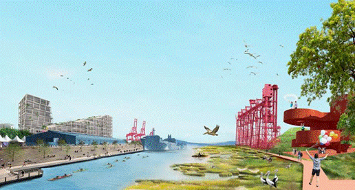
In San Francisco’s Bayview district, a design team that includes the high-profile Danish architectural firm Bjarke Ingels Group, will focus on Islais Creek. The waterway would be enlarged by 300 acres to create semi-natural shorelines to absorb the impact of higher tides and stronger storms.
.
This would take away existing land and give it back to the bay. But dense development would be allowed along the edge as a trade-off — part of an effort, Ingels intones in a video, to break down “traditional silos of city-making.”
The 10 teams won’t be starting from scratch.
The competition kicked off in June and the winners were selected in September, with each receiving $250,000. Three months were spent on visits to potential sites.
The months ahead will be spent burrowing into the specific locations, and reaching out to the surrounding communities to make sure there’s widespread participation in the final proposals.
“What we do next is expand the circle,” said Nicholas de Monchaux, an associate professor at UC Berkeley’s College of Environmental Design. He’s part of the All Bay Collaborative, which includes design firms AECOM and CMG Landscape Architecture as well as students from Cal and the California College of the Arts.
This team’s focus will be San Leandro Bay and its neighbors, such as the Oakland Coliseum. One idea it is exploring involves “tidal cities,” where new horizontal levees would shield existing neighborhoods — and include clusters of floating structures within lagoons that could help absorb groundwater that might otherwise flood inland areas during the winter.
San Rafael and East Palo Alto also drew attention from the collaborative during the fall. But they were assigned to other teams.
“I wouldn’t have wanted that job,” de Monchaux said. “There were a lot of good ideas for a lot of places kicking around.”
So far, local politicians seem comfortable with the idea that teams of architects and planners and engineers — some from outside the region, others from out of town — will be offering elaborate suggestions on what shape the local communities’ futures might take.
“Having the opportunity for a world-class team to look at our shoreline, that’s not something we would want to pass up,” said Richmond Mayor Tom Butt.
Butt is on Resilient by Design’s executive board. Richmond was selected as one of the sites even though it passed its own adaptation plan in 2016.
“They might bring us something out of the box,” Butt explained. “Something we haven’t thought of before.”
John King is The San Francisco Chronicle’s urban design critic. Email: jking@sfchronicle.com Twitter: @johnkingsfchron |