|
| Point Richmond has always been a quirky place, filled with characters and intrigue -- artists, heroes, villains, musicians, poets, drunks, druggies, professors, rogues and scoundrels. It was a hidden outpost for UC Berkeley professors from the 1930s through the 1960s, and many of them had noteworthy mid-century modernist homes designed by architects affiliated with UC Berkeley.
One of the most famous heroes was Walter Horn (Walter Horn, Monuments Man From Richmond and the Crown Jewels of the Holy Roman Empire, January 11, 2016), who built a home in Point Richmond in 1942 and lived here for years after he returned from WWII.
In the 1960s, Point Richmond was home to Richmond’s colorful hippie Mayor David Pierce (Fear and Loathing in Point Richmond? July 6, 2013, and They Don't Make Mayors Like This Anymore, September 11, 2016), who also hung out with Hunter Thompson.
One of the Point’s most infamous, although transitory, residents was Owsley (“Bear”) Stanley, the “King of Acid,” who occupied a house in Point Richmond from approximately July 1966 to October 1966, using it as an LSD lab. Owsley was a genius who also served as the Grateful Dead’s soundman. He did not invent LSD, but he perfected it, became perhaps the world’s largest manufacturer and made it culturally famous. Robert Greenfield (“The Life and Times of Augustus Owsley Stanley III”) writes:
Still living in Berkeley, Owsley had now also rented a house in Point Richmond, an industrial neighborhood in Contra Costa County at the eastern end of the Richmond San Rafael Bridge. Working alongside Tim Scully and Melissa Cargill in a basement laboratory there, he had manufactured what may have been more than three hundred thousand tabs of powerful acid, each of which contained 270 micrograms of LSD.
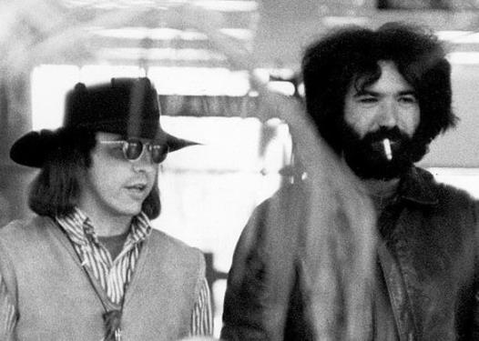
Owsley Stanley(left) with Jerry Garcia, September 1968
From "The Brotherhood of Eternal Love": "
Owsley got out of the Volkswagen and looked across the bay from Point Richmond towards San Francisco, sniffing the air appreciatively. Anyone watching might have doubted his sanity. Point Richmond was a little cove with lots of -pretty timber-frame houses and nice neighbors like Berkeley professors, but the smell on the wind was not pleasant. Point Richmond stank. Near to the houses was a large refinery belching out all manner of fumes. But that was fine for Owsley. With all those refinery smells, no one would ever notice the fumes from an LSD laboratory.
Another advantage possessed by the neighborhood was that no one was likely to suspect a laboratory among the professors and artists who lived around there. The actual house he planned to rent had its own special attractions: located right on the edge of the bay, the white timber home stood in such a position that it could be kept under surveillance from only two spots, both of which could be checked before anyone approached the house.
The living quarters of the house were built above the garage and the basement, which ran into each other. The basement could be partitioned off to form a laboratory area; and chemicals and equipment could be driven almost straight in without anyone on the street outside seeing what was happening. The house had one other little feature which appealed to Owsley's sense of melodrama. The basement could be reached from the house above through a trap-door that was hidden under a rug in a cupboard in the bedroom.
The police raid on his methedrine factory had taught Owsley the virtues of caution and security, almost to the point of paranoia. He was always careful to be late for appointments, to vary his movements and check whether he was under surveillance. So, when he came to consider laboratory sites, he sat down and thought out his requirements with great care. Point Richmond was the 'prototypical underground laboratory'.
Owsley, Scully and Melissa Cargill moved there early in the summer of 1966. The couple slept in the house's only bedroom while Scully and any visitors bedded down on the lounge floor. To make sure no one could see into the basement from the road, they set up sheets of plywood, dividing it from the garage."
For some time, I have been trying to locate Owsley’s lab, perhaps to place a bronze historical plaque on it. I tried to get 1960’s icon former Mayor David Piece to locate it when he was in Point Richmond a few months ago, but his memory had faded.
I got fired up again after hearing Robert Greenfield talk about his book, “The Life and Times of Augustus Owsley Stanley III,” at Book Passage in Corte Madera. It turned out Greenfield was no help, but I was able to locate Tim Scully, another genius who worked in Owsley’s lab in Point Richmond. Tim Scully, in turn, contacted Melissa Cargill (now Jeffress) and some other friends from back in the day who have been trying to provide enough recollections to locate the house.
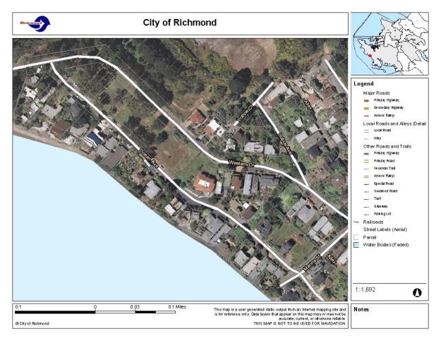
Based on their best recollections, the house was on the upslope of either Western Drive or Ocean Avenue, probably north of Marine Street. Tim’s detailed recollection of the floor plan is amazing considering it was 50 years ago and a lot of acid was ingested.
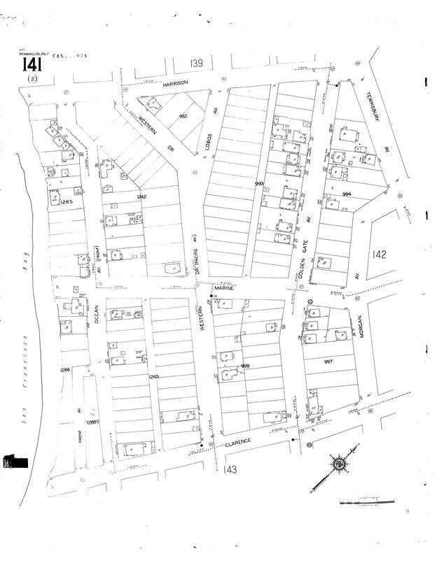
I have assembled and poured over aerial photos from 1958 and 1968, the Sanborn Map from 1951 (the last one) published, and of course, GIS data from the City of Richmond and Google Earth. I have some knowledge of the neighborhood because I lived at 611 Western Drive for several years, beginning in the fall of 1973.
I have focused on upslope houses because the older homes are typically the ones that have two stories with a garage under facing the street, and this fits best with Tim Scully’s recollection.
The location of the house remains elusive. It may have been torn down, burned, or remodeled beyond recognition. I also went to Next Door Point Richmond to solicit help from old timers and got some good hints and eliminated some possibilities, but still no success.
Now, I am posting what I have on my E-FORUM.
By a process of elimination, this is what I have:
Western Drive North of Marine Street. The only candidate might be 800 Western Drive prior to a major remodel.
- 747 Western Drive is not in the 1958 aerial photo but is in the 1968 aerial photo, but it is accessed from Lobos Avenue behind. It has no driveway or garage off of Western. It is accessed from Lobos Court behind and is not the right design or layout. Not a candidate.
- 754 Western Drive is in the 1958 aerial photo but is either not in the 1968 aerial photo, or it is obscured by trees. It has no driveway or garage off of Western. It is accessed from Lobos Court behind and is not the right design or layout. It is one-story as it faces Lobos Court. Not a candidate.
- 778 Western Drive . The only house on the uphill side of Western Drive in this block in the 1951 Sanborn Map. It appears I both the 1958 and 1968 aerial photos. This was the Eakle residence going back to before the 1960s. It has no driveway or garage off of Western. It is accessed from Lobos Court behind. Not a candidate.
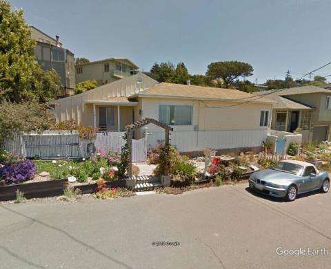
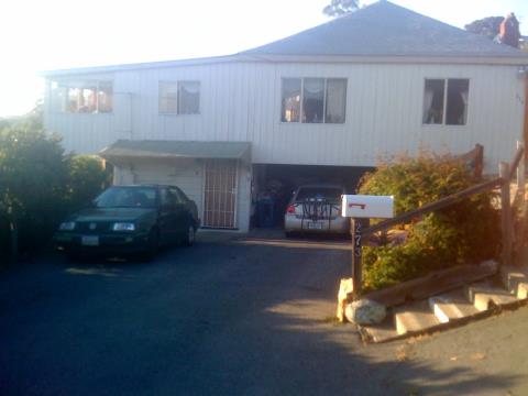
- 800 Western Drive is in both the 1968 and 1968 aerial photos, but it is impossible to discern its configuration. Today, it looks nothing like Scully’s sketches and appears to have been substantially remodeled. Bernadine Riordan writes, “What about 800 Western? Living room over garage, adjacent basement (a previous owner finished it out without permits about 10 years ago), looks across Chevron property to bay, driveway to one car garage, fairly level,1 story.” It has a driveway from Western Drive. This is a possibility, but not strong.
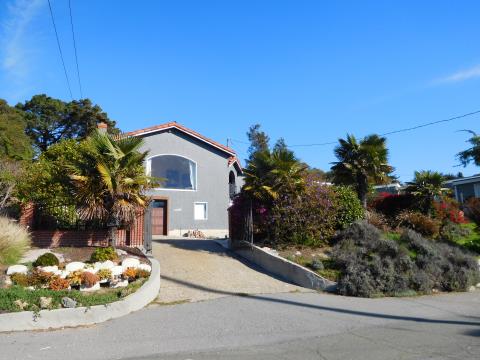
800 Western Drive
- 808 Western Drive is in both the 1968 and 1968 aerial photos, and it has a driveway from Western. It is two stories with a garage under. It would seem to be a candidate, but Emil Munkres write, “808 Western Drive was the home of Max and Mae Mandl. I'm not sure when they moved in but I know they were there from at least 1962. Phone - BE5-8693. Mae was a Board member and Treasurer of the Point Richmond History Association in the 80's. I think she lived at 808 Western at least into the 1990's. She died in 2004 at age 97.” Scully writes, “The large windows in both your candidates [808 Western and 746 Ocean] seem to be on the wrong side. I recall sitting at the kitchen table facing toward the bedroom and bath, and I don’t recall a large window on my left, in fact I don’t recall any window there. Not a candidate.
Ocean Avenue North of Marin Street. The only candidate might be 762 Ocean Avenue – the site but not the present house.
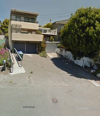
- 700 Ocean Avenue. There was a house on the 700-708 lot on the 1951 Sanborn Map. It also shows up on the 1958 and 1968 aerial photos. I moved to Point Richmond in 1973, residing just a half block away at 611 Western. I remember this house was undergoing a a extensive but very strange remodel. The original house may have been torn down or burned, or it may have been incorporated into the remodel. There is no evidence, however, of a driveway or garage facing Western Drive. Not a candidate.
700-708 Western Drive
- 726 Ocean Avenue. There was a house here on the 1951 Sanborn map as well as the 1958 and 1968 aerial photos. Fostiak recalls: “726 (Ocean) is the de Benidictus house. Remodeled in the 50's. Was a small ground level cottage with an unattached garage adjacent. Two story bedrooms added in back mid-fifties. Worked on again about twenty years ago.” Ironically, I rented this house for a few month in about 1976 after selling 611 Western Drive. It just doesn’t fit Scully’ plan. Not a candidate.
- 744 Ocean Avenue. There was no house here in 1951, but a rectangular house shoes up on the 1958 and 1968 aerial photos. It may have been torn down, because the one at 744 Ocean today appears to be more contemporary. It has a garage under what appears to be a bedroom, but the rest of the house does not have a full basement. Not a candidate.
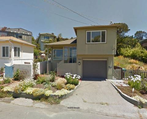
744 Ocean Avenue
- 754 Ocean Avenue. This house is on the 1951 Sanborn Map and the 1958 and 1868 aerial photos, but it is a single story with no garage or driveway. Not a candidate.
754 Ocean Avenue
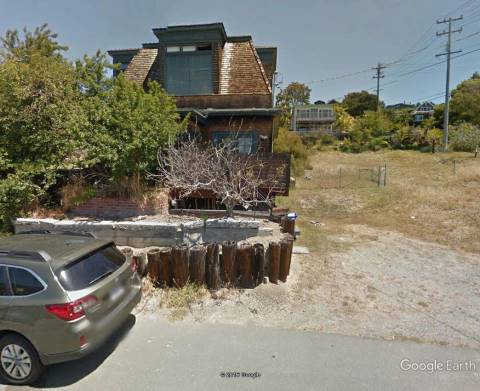
- 762 Ocean Avenue. There was a house at 762 Ocean Avenue on the 1958 and 1968 aerial photos, but the house here now is three stories and is of contemporary design, probably later than the 1960s. The original house must have been torn down.
Fostiak: Look at 762 Ocean. It best fits the criteria of refinery side of Marine, hill side of street and capable of counter-surveillance from above. I believe all the houses on the refinery side of Western were occupied by knowns at the time but they also don't lend themselves to the watching. Further, if you take the hillside as the primary filter, as the one least likely to be misremembered, none of Western could be watched from above all the way to Washington but for one and it doesn't fit. So it's Ocean. Five houses refinery side, three occupied by knowns, the fourth I can't recall by whom but I am pretty sure was a long-time resident. The other end of Ocean could be watched from above but I remember only three and none were over a garage.
The location may be a candidate, but not the house.
771 Ocean Avenue on the left and 762 Ocean Avenue tucked in on the right
There was a house at 7671 Ocean Avenue on the 1958 and 1968 aerial photos, but the house bears no resemblance to Scully’s sketches. It is two stories, but not wide enough, and there is nothing over the garage but a deck. Not a candidate.
Source Material from NextDoor postings:
- Roca: 808 Western fits the location description, but the floorplan is totally different. It has a single car garage & no basement. The living room is on the right, not the left….Fostiak: Do you know this because you've been inside? Because the view of the footprint when examined on google map suggests that it fits the description rather well. "My memory is that the building was basically square and the missing part of the square on the sketch is where the steps and front porch were." Roca: Yes, Peter, I have done a lot of work on that house. There is only a crawl space under all of the house other than the single space garage. Further, the lack of windows on the ground floor would indicate a basement.
- Emil Munkres: 808 Western Drive was the home of Max and Mae Mandl. I'm not sure when they moved in but I know they were there from at least 1962. Phone - BE5-8693
Mae was a Board member and Treasurer of the Point Richmond History Association in the 80's. I think she lived at 808 Western at least into the 1990's. She died in 2004 at age 97.
- Emil Munkres: People's memories do tend to fluctuate with the passage of time, and an increase in LSD consumption way back when certainly bumps up the memory fluctuation factor considerably. My money's on 420 Western, but it's the wrong location and the wrong layout and my recollection is a little fuzzy.
- Bernadine Riordan: What about 800 Western? Living room over garage, adjacent basement (a previous owner finished it out without permits about 10 years ago), looks across Chevron property to bay, driveway to one car garage, fairly level,1 story.
- Fostiak: 726 (Ocean) is the de Benidictus house. Remodeled in the 50's. Was a small ground level cottage with an unattached garage adjacent. Two story bedrooms added in back mid fifties. Worked on again about twenty years ago. I remember the lot at 700 being empty in the 50's.
- Emil Munkres: City Directories show a Paul E. Heater renting a home at 710 Ocean Ave in 1960-61 and 1962-63. Phone BE5-2643 . In the 1964-65 directory, 710 Ocean is listed as vacant. Don't know when this house disappeared.
- Emil Munkres: Other upside addresses listed as vacant in 64-65: 628 Western, 646 Western, 540 Ocean (all south of Marine)
- Emil Munkres: 800 Western, 726 Ocean and 744 Ocean were all continuously occupied through the mid 60's.
Source Material from Scully and Friends
- Scully 12/2/2016: Bear and Melissa rented the house where the lab was located in about August 1966 and we closed the lab down in about October or November 1966, not long after the Grunsky Bill finally took legal effect in October. Those dates are accurate plus or minus a few weeks at most. Bear chose Point Richmond as a lab location partly hoping that smells from the refinery would mask lab odors, partly because he hoped that the artist colony nature of the community would tolerate eccentricity more than other neighborhoods and partly because the topography allowed us to do counter-surveillance from the hillside above the house when returning to the lab from running errands. And of course Point Richmond is simply a nice place.
The lab was either on Ocean Avenue or on Western Drive, on relatively low ground fairly close to the bay. I realize those streets don't run north and south but rather at a diagonal, but for the sake of simplifying discussion allow me to write as though they run north and south with the bay to the west of them and Richmond to the east.
The house for the lab was located was on the east side of either Ocean Avenue or Western Drive and I'm fairly sure north of Marine Street where notional north is the direction toward the bridge and the refinery. I believe there was a vacant lot to the north and possibly across the street to the West.
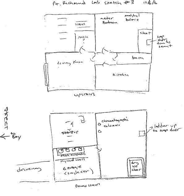
It was a one-bedroom house built over a garage and an unfinished more or less ground-level "basement." The living room was over the garage and faced toward the bay. The bedroom was east of the living room as was the kitchen. There were stairs going up to the front door which opened into the living room. There was a trap door in the bedroom closet and a ladder that went down to the basement.
- Scully 12/3/2016: The sketch of the house shows it looking from the street toward notional East; notice the driveway leading into the garage. My memory is that the short driveway led directly from the street into the garage without turning a corner. My memory is that the building was basically square and the missing part of the square on the sketch is where the steps and front porch were. I couldn't remember the exact orientation of the steps relative to the porch and so I hesitated to draw them in.
I'm not sure whether the house was on Ocean or Western but I think Western is more likely.
- Scully 12/4/2016: The large windows in both your candidates [808 Western and 746 Ocean] seem to be on the wrong side. I recall sitting at the kitchen table facing toward the bedroom and bath, and I don’t recall a large window on my left, in fact I don’t recall any window there.
I have a vivid memory that the trap door in the bedroom closet leading down to behind the chromatographic columns in the dirt-floored basement area behind the garage and of the living room being over the garage with large windows facing the street.
But, of course, memories can change over the years as they are revisited and fondled. Neither of the two houses seems right to me, but I’m going to pass your PDF on to Don and Melissa and see what they think.
Meanwhile I received this from Don: [from Don Douglas] Hi and thanks, Tim. I remember driving down and then up again, but not steeply, with the house in a saddle sort of like the one at 628 Western. However, the house currently at that address itself is newer and nicer.
- Scully 12/5/2016: That [273 Bishop] is definitely not the right house. It is in the wrong area, the wrong shape, etc.
I’m leaning toward 808 Western because of the garage on the left. But I ‘m troubled by the big window where I remember the kitchen being.
My memory is that the garage was on the left, facing the house. I recall the living room being over the garage, as in 44 Dillon. But I recall the front steps were concrete and to the right of the garage, going up to the living room door. The one bedroom was behind the living room. Then there were the bath and the kitchen. We (or at least I) used to crash in sleeping bags on the living room floor while Bear and Melissa occupied the bedroom.
- Scully 12/5/2016: Here’s a slightly revised sketch of my memory of the floor plan.
The lab was partly in the garage (on the far left, behind a plywood partition) and in a dirt floored room behind the garage and front stairs.
You memory of the garage on the right comes close to matching the two houses that Tom proposed in the PDF.
SO3 was the chemical that got tossed into the bay once.
- Don Douglas 12/4/2016: My recollections are primarily of the interior, especially the ground-floor lab, as we didn't spend a lot of time outside the place. However, there was one incident where Melissa and I went shopping in their VW Beetle. Returning with a couple bags of groceries, just before reaching the lab house, I sensed strongly that we were being followed and at the last moment I didn't turn in the driveway. The cool thing to do would have been to continue driving at an even speed until they were ditched and then return. Being new at it and very nervous, I sped up. At least that was better than turning in and thus telling them where the lab was. That episode made an imprint on my memory and is why I mention the down slope followed by an up slope, with the house at the low point of a saddle. If the mayor can find the aerials or street photos that you requested, it would be a big help. I still think 628 Western fits what I remember of the road, but the house is too new. I wonder when it was built/remodeled.
- Don Douglas 12/4/2016: No, for whatever reason I failed to scroll down to see the PDF. Thanks for reminding me. Anyway, 746 Ocean looks like a better fit to what I remember than 628 Western. The design was similar to the house I later bought in Dillon Beach, at 44 Ocean View Avenue, except reversed left-to-right. At the lab, the garage was on the right as you face the house. I don't remember what was on the ground floor alongside the garage. The lab, of course, was at the back of the house, behind the garage. The trap door should have made an impression on me ? how many houses have them? ? but I guess it didn't. I can't call up a mental image of it. In Dillon Beach, there was nothing alongside the garage, just posts sitting on piers and the requisite framing. In Point Richmond, I don't remember at all. There could have been rooms. It's quite possible that we mostly only went there to work and, perhaps except for napping, still slept at Hopkins Street. It's weird what one remembers. One little thing that made a big impression on me was the humanoid potato bugs crawling through the lab, one in particular which (whom?) I killed with a squirt from a squeeze bottle of acetone.
What was that substance that reacts explosively with water? Remember Bear walking down to the bay and tossing out a flask of it? A recollection of that walk might help with remembering the house.
- Scully 12/5/2016: I’m uncomfortable with the living room on the right and the fireplace at 808 Western (which I don’t recall). The wooden stairs and the balcony also are jarring.
Don asked if I recalled us running to the bay to get rid of an open ampoule of S03. I do. I recall running with Bear and maybe Don toward the bay from the garage door. But my mental picture is very foggy. I think it was nighttime. We must have had direct access to the bay without being right in anyone’s yard.
Don Douglas 12/5/2016: Bear and Melissa didn't often have fights in front of us, but did one time at the Point Richmond lab that I recall. She was very upset with him about his philandering and it got quite heated. My picture of it was that we were standing in the living room, their bedroom was on the northwest side (the left as you face the house) and the living room was on the southwest side.
I also remember driving toward the bay on a road such as Marine, turning left toward the house, and then turning away from the bay at the next corner. That would not fit with the location at 808 Western where one enters from one end and loops around. Also, Ocean Avenue doesn't fit with what I recall with respect to driving because it doesn't go through. The best fit road-wise is the 600 block of Western. 628 appears to have been built on two lots, so it seems possible to me that the house we used was torn down and replaced with a much larger one.
- Melissa (Cargill) Jeffress 12/6/2016: I don't remember the floor plan, other than garage below, house above. I do remember the trapdoor and the ladder.
Of the first two houses suggested as possibilities:
1) I do not recognise anything about the photo of house at 808 Western Dr (which may have been remodeled in the interim, as mentioned, which could explain lack of recognition).
2) I did feel a gut reaction to the photo of the house at 746 Ocean.... The garage on the right feels correct and that entrance to the house has something familiar about it.
- Scully 12/6/2016: I’m going to go with the majority vote and move the garage to the right [Floor Pan #3].
I agree with Don that 746 Ocean is close but no cigar because it is split-level. But it sounds as though we may be converging on a description.
- Scully 12/11/2016: Thank you for the sketch. It doesn’t resonate strongly for me, perhaps because my fuzzy memory is that the house was stucco and that the stairs may have been concrete. I believe the front door opened into the living room.
I’m conflicted about the relative positions of the living room and kitchen but I’m confident that the living room and bedroom were adjoining and the bath separated the bedroom and kitchen. My ambivalence is whether the living room was over the garage as in Sketch #3 or if it is to the left looking from the street as in my earlier sketches.
- Don Douglas 12/16/2016: Speaking for myself, it's a myth that hindsight is 20-20. I do recall that the bedroom was on the right as you stand in the living room facing toward the bay, but I have no visual recollection of the kitchen whatsoever, nor of the trap door, etc. Probably we were driven there, since leaving a recognizable car such as the Hillman sitting in the driveway would not have been wise and the garage only held one car.
There does seem to be a connection between adrenaline and memory, because I recall that episode where I was driving Bear and Melissa's VW, with her in the passenger seat, as though it were much more recent. The sense that we were being followed hit me after we had turned left onto the street and another car followed us around the corner. I sped up and continued on, turning left again (or possibly angled left onto Contra Costa) to go back toward town. The only street that fits this memory is Western Drive.
Looking at the difference between the 1958 and 1968 aerial views that Tom provided confirms my belief that a house on a single lot at 628 Western was replaced by a much larger one. The current house appears white in the 1968 view, although Goggle satellite view and common sense would suggest a darker colored roof. I think the white is perhaps a concrete slab, suggesting that the current house was built or extensively remodeled in 1968.
Maps
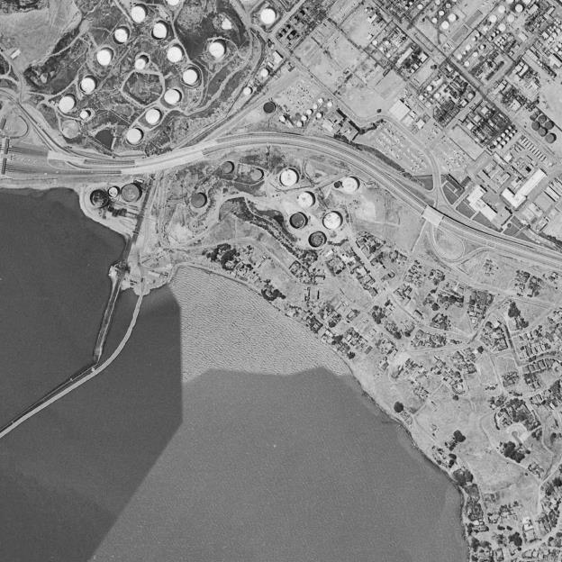
Aerial Photo 1958
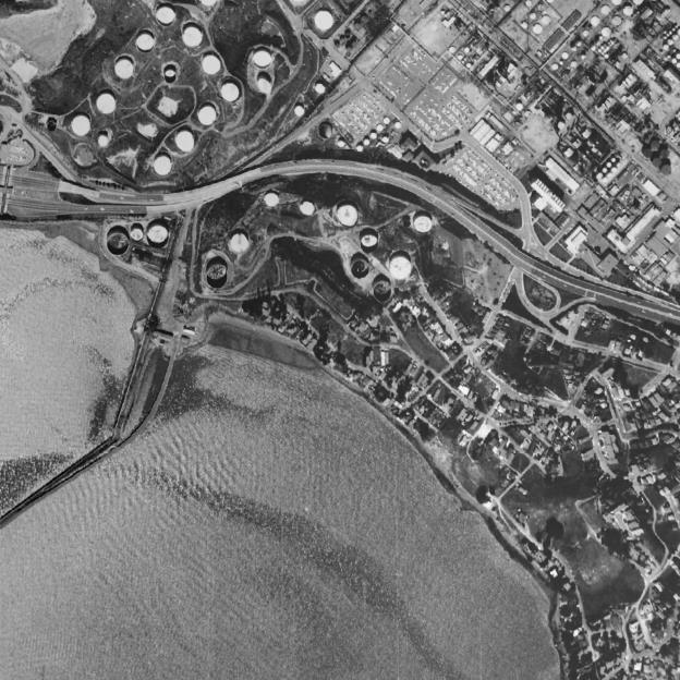
Aerial Photo 1968
Aerial Photo 2009
Sanborn Map 1951
Scully Sketches
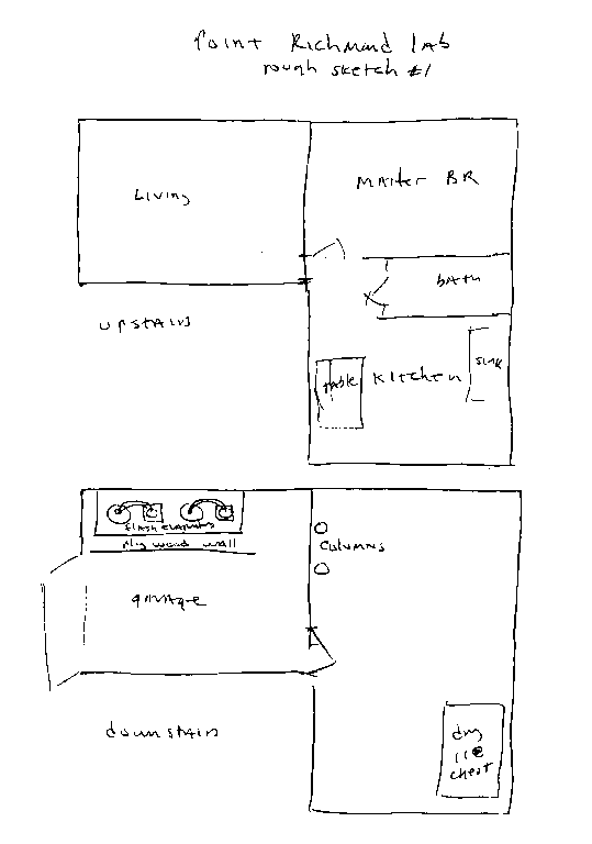
Scully Floor Plan #1 (12/2/2016)
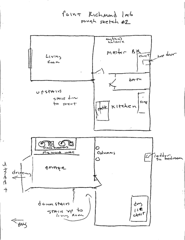
Scully Floor Plan #2 (12/5/2016)
Scully Floor Plan #3 (12/6/2016)
From: Susie Davis
Sent: Sunday, December 04, 2016 3:52 PM
To: Butt, Tom
Subject: Owsley's House
Hi Tom,
How interesting to read your post in Nextdoor looking for information about Owsley’s Point Richmond Lab. I and my friend David Roche have been doing just that and have had a number of correspondences around it.
David found this article on line. It used to have a map that showed the locations of key locations including the Richmond lab. Since then the link to the map has disappeared.
https://henrywarrick.wordpress.com/2011/03/15/owsley-stanleys-legacy/
While the map was up David wrote this to me:
"Here's the piece on Owsley. If you go to the Google map in the story and drill down on the San Francisco flag, a second, Richmond flag pops up. Drill down farther and the flag in Pt Richmond is placed on a lot on Bishop Avenue at the place that I located earlier - I think "273" is on the mailbox. I never spoke with the current renters/owners so have no idea that that's the spot. But Owsley must have informed this guy of the location since it looks to be pinpointed.”
Later on David contacted Tim Scully and sent him a photo of the house at 235 Bishop. He later wrote to me.
“Tim Scully neither confirmed nor denied my guess as to the Owsley house at 273…. his email address no longer works and I couldn't track him further. An Australian journal on Owlsley published a rough map and with that I figured I'd nailed the location....very near your house and mine. I walk by and imagine the bathtub factory. And a guy I spoke with at the Historical Society was completely clueless and uninterested. I never spoke with the current tenants at 273 (Bishop? Western? - right at the fork in the road north of Washington) so don't know if they have any further info. Only the mysterious Scully holds the key to the mystery”
Here is the email he sent to Tim Scully
On Sunday, November 30, 2014 6:44 PM, Susie Davis <sdavismusicgal@icloud.com> wrote:
Begin forwarded message:
From: David Roche
Subject: Pt. Richmond lab?
Date: August 26, 2013 4:43:32 PM PDT
To: timscully@yahoo.com
Cc: Susie Davis <poserdlx@sbcglobal.net>
Reply-To: David Roche
Hi Tim, I think I've located it, thanks to a Deadhead's map online. One bedroom between two vacant lots. Very near junction with Western and Washington. I spoke with the VP of the local historical society who knew lots about distilleries in the Point during Prohibition but knew nothing about the Lab That Changed the World in 1966. If this looks like it, I can find out more. David
This is the information about Owlsley that I put together for whe I take people on my “Weird Pt Richmond” tour!
Please keep me posted if you find anything new from your sleuthing!
Thanks
Susie Davis
Owsley’s Lab 273 Bishop Avenue
In July 1966 Owsley rented a house in Point Richmond, California and Owsley and Melissa Cargill (Owsley's girlfriend who was a skilled chemist) set up a lab in the basement. Tim Scully worked there as Owsley's apprentice. Owsley had developed a method of LSD synthesis which left the LSD 99.9% pure. The Point Richmond lab turned out over 300,000 tablets (270 micrograms each) of LSD they dubbed "White Lightning".
the famous White Lightnings that were handed out by the thousands at the HumanBe-In celebration in January, 1967
Owsley was arrested on Christmas Eve 1967.
In late 1967, Stanley's Orinda lab was raided by police; he was found in possession of 350,000 doses of LSD and 1,500 doses of STP. His defense was that the illegal substances were for personal use, but he was found guilty and sentenced to three years in prison. After he was released from prison, Stanley did more sound work for the Grateful Dead and later worked as a broadcast television engineer.
Busted with the Dead in New Orleans On January 31, 1970. Stanley was charged with illegal possession of narcotics, dangerous non-narcotics, LSD, and barbiturates. According to an article in the Baton Rouge State Times, Stanley identified himself to the police as "The King of Acid" and technician of the band. Based on this incident, the Grateful Dead wrote the song "Truckin'" (1970)
Stanley was confined to federal prison from 1970 to 1972, after a federal judge intervened and revoked his release from the 1967 case. Stanley took advantage of the opportunity there to learn metalwork and jewelry-making.[3]
In early 1973 Billy Hitchcock (who financed tim Scullly’s lab in Colorado) was threatened with 24 years in prison for tax evasion if he didn't help the government convict the prime movers of the LSD cartel. Billy provided evidence and testified against Tim Scully and they were both indicted in April 1973. Scully's defense was that he was producing ALD-52, which was legal, and not the controlled substance LSD-25.[4] Scully lost the case and was convicted and sentenced to 20 years in prison in 1974. Scully's appeals ran out in late 1976, so he sold his stock in his company and began serving prison time in early 1977.
Scully spent his time in prison helping design and build biofeedback and interface systems for the non-vocal handicapped. Scully's sentence was reduced to 10 years and he was released from prison on parole in 1980.
|
|