The article copied below from Richmond Standard describes a project recently in the news that would add a third east-bound vehicle lane to the Richmond-San Rafael Bridge as well as a bike lane crossing the bridge on the uper deck with the existing two west-bound lanes. The driving force for this project is to relieve traffic congestion accross the bridge in the evening as East Bay residents working in Marin and other North Bay locations return home.
Because the third lane would displace an existing legal but deadly bike lane that provides access to and from Point Molate at the eastern end of the bridge, Caltrans is obligated by law to mitigate the loss of the bike lane.
There has been a project working its way through the approval process that would have provided an elaborate and expensive “flyover” bike lane and pedestrian Bay Trail spur to Point Molate on the south side of I-580 at the east end of the bridge. There is, however, no souce of funding for the estimated $30 million project.
Meanwhile, Caltrans and the Metropolitan Transportation Commission have proposed a much less expensive Bay Trail connection to Point Molate on the north side of I-580 that would fit on a modified shoulder (see renderings below). Caltrans has previously been vigorously opposed to the north side route, but powerful political interests in wealthy in Marin County have been able to turn the tide, and Caltrans has shown some uncharacteristic flexibility towards accommodating means of transporation other than motor vehicles.
Plan in works to add third eastbound lane and bike path on Richmond-San Rafael Bridge
January 24, 2015 by Mike Aldax
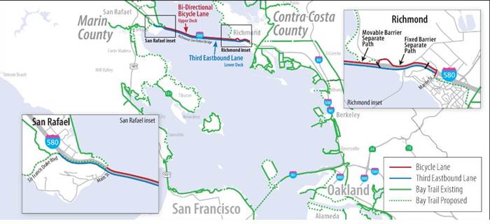
A $74 million project undergoing environmental review would add a third eastbound lane on the Richmond-San Rafael Bridge and a bike/pedestrian path on the span’s upper deck.
On Friday, Richmond Mayor Tom Butt forwarded a project fact sheet from the Contra Costa Transportation Authority that estimates the vehicle lane and bike/ped path could be completed by 2018.
The project would convert the existing shoulder on eastbound I-580 to a third travel lane between Marine Street in Contra Costa County and Sir Francis Drake Boulevard in Marin County.
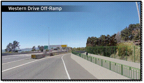
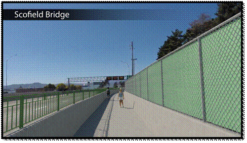
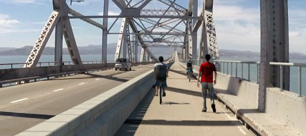
The plan also includes a bi-directional bicycle lane on the upper deck. The 10-foot-wide bike/ped lane would be separated from traffic by a moveable concrete barrier system similar to the one that was just installed on the Golden Gate Bridge.
(click below image to enlarge)
 The project is not cheap. The eastbound lane portion is estimated to cost $30 million, while the bike/ped path is estimated at $29 million. A $15 million contingency was included in the total estimate. The project is not cheap. The eastbound lane portion is estimated to cost $30 million, while the bike/ped path is estimated at $29 million. A $15 million contingency was included in the total estimate.
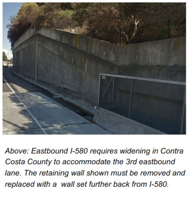
But the project isn’t so simple. The wall along eastbound I-580 will need to be removed so that the highway can be widened to accommodate a third lane:
The bicycle and pedestrian path would add another crucial link to the planned 500-mile San Francisco Bay Trail connecting 46 Bay Area cities.
On Tuesday, legislation was introduced requiring the design phase of the eastbound lane to begin while the project is undergoing environmental review. That could speed up the project by up to 18 months, according to the Marin Independent Journal.
“This project will reduce commute times substantially,” Jim Wunderman, president and CEO of the Bay Area Council, told the IJ. “Congestion on the bridge extends all the way to Highway 101 and affects not only commuters on the bridge, but also commuters heading north.”
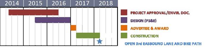
Here is the projected timeline for the Richmond-San Rafael Bridge proposals:
|