City goes green with tree counters
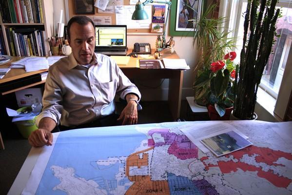
“In terms of pushing the city in a positive direction, I don’t think there’s any better thing we could be doing,” said landscape architect JC Miller, on planting more trees. (Photo by: Zach St. George)
By Zach St. GeorgePosted 47 minutes ago
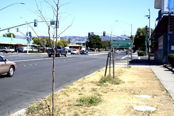
Near the corner of Cutting Boulevard and 23rd Street, between an asphalt parking lot and a concrete sidewalk, surrounded by weeds and yellowed grass, is a dead tree. Finger-thin, shoulder-high, it leans drunkenly. How long it’s been there and how long it’s been dead nobody can say. Most city maintenance crew maps probably show the leafless tree as alive and well, if it is marked at all.
But that’s about to change. Richmond’s estimated 28,000 street trees will be indelibly on the maps after surveying teams finish collecting information on every one of them this fall. Richmond recently won two grants, totaling more than $500,000, to make the city a greener place. The tree inventory, set to begin in a couple of weeks, is the keystone of the project.
“In terms of pushing the city in a positive direction, I don’t think there’s any better thing we could be doing,” said JC Miller, a landscape architect hired by the city to run the inventory. The walls of Miller’s Point Richmond office are covered with paintings of trees and 3-D models of landscaping projects. Potted plants fill the space below the window. Miller leans over a map of Richmond, divided into a dozen brightly colored zones—not much of it green, he said.
“The legacy of refineries, railroads, industry, hasn’t positioned Richmond as a very leafy place,” he said.
That’s too bad, he said, because trees benefit city dwellers. They provide shade, clean the air, and reduce runoff and pollution. They can even increase property values.
Richmond has hundreds of miles of boulevard strips— the two or three-foot wide area, usually grass or bare dirt— between sidewalk and street. Right now, many of them are empty, but there could be trees there, he said.
The city recently finished an initial tree count, paid with money from the first grant, from the California Strategic Growth Council. It was a rough survey, Miller said, and only tracked where trees are, whether they’re dead or alive, and their approximate size.
Even that was a vast improvement from what the city knew previously. The computer program Richmond used for years to track its trees had become dated, he said—so dated that the only computer that could run the program had been relegated to a back corner in the Parks Department office, where it had gradually fallen out of use. City workers had reverted to keeping their tree records on paper, he said, which made it near-impossible to get big-picture data on the city’s trees.
The initial survey found that, like the tree on Cutting and 23rd, as many as 30 percent of the trees on the city’s maps were dead or no longer there, Miller said, victim to the cars, pollution and lack of water that commonly fell roadside trees.
While the city updates its maps, the next survey, paid for by a joint Cal-Fire and U.S. Forest Service grant, will give it a more detailed picture of its urban forest. Two teams of two will spend two to three months patrolling the streets of Richmond, stopping at every tree on city-owned land. Using a computer tablet, they’ll record its address and GPS coordinates, its species, height and diameter, and its condition. Later, they’ll enter the data into a Department of Agriculture-developed tree management program called iTree. Using the GPS data, they’ll create a digital map that can be layered over and compared with maps of economic, development, or population data.
The tree counters will also mark potential places to plant trees, which Miller said is nearly as important as the survey itself. Knowing where trees are needed will make it much easier for the city to point Richmond’s various nonprofit and private tree planters in the right direction.
In large part because of the tree count, the map, Miller said— sweeping his hand over multi-colored rendering of Richmond— will be greener and greener as time goes on.
Meanwhile, James MacNair, the arborist Miller’s firm subcontracted with to conduct the survey, is preparing to train his team of tree counters. “There are a lot of variables,” MacNair said. He’ll school his recruits— probably two master gardeners and two landscape architectural students or recent graduates— on how to identify species, how to measure trunk diameter and height, and how to assess threats the tree poses to nearby sidewalks, and overhead power and communication lines.
The biggest hurdle, MacNair said, is overcoming the fatigue that sets in after measuring hundreds of trees for hours on end. “You have to have the right personality for it,” he said. “Takes a person that can stay focused for that length of time. Some people really like it.”
MacNair said he’s run many similar tree counts, including a recent count in El Cerrito. Neighborhood people usually aren’t too interested in the safety-vest-wearing tree counters, he said, but sometimes their dogs are. “I worry about damn pitbulls,” MacNair said, laughing.