Attached for your enjoyment and information is the 13th Richmond Bay Trail Mid Year Report. This upbeat, colorful report features kudos to Richmond’s Bay Trail from the State Coastal Conservancy, progress toward closing five major gaps totaling over three miles and completion of the 2.4-mile Shipyard 3 Trail.
Please share this report with your friends and neighbors either by forwarding this email or by printing the report for display in your home. Let them know that they may receive news about Bay Trail events and progress at no cost by emailing tracbayrail@earthlink.net.
For maps, the calendar of events and other information about the Bay Trail in Richmond, please visit TRAC’s award-winning website designed and maintained by David Moore of Sincere Design. Enjoy the Bay Trail in Richmond!
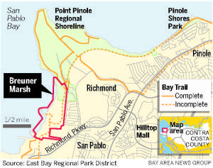
Referring to the attached Contra Costa Times article, East Bay Regional Park District (EBRPD) Board of Directors voted on July 3 to certify the Final EIR and approve the plan to close a 1.5-mile gap in the San Francisco Bay Trail while restoring tidal and seasonal wetlands on the former Breuner property south of Point Pinole Regional Shoreline. When completed during the 2013 − 2015 period, this project will provide long-awaited Bay Trail access to the largest shoreline park in the Bay Area.
Click Here for more information about closing the four miles of Bay Trail gaps on Richmond’s northern shoreline, including EBRPD’s plans for Bay Trail access from Atlas Road to the east and Pinole to the north. Come to the 7th annual North Richmond Shoreline Festival on October 6 to learn more about this beautiful stretch of shoreline.
Plan approved to restore Breuner Marsh and open it to public
By Denis Cuff
Contra Costa Times
Posted: 07/03/2012 06:42:14 PM PDT
Updated: 07/03/2012 07:09:26 PM PDT
Preparing to turn part of the San Francisco Bay shore back to nature, a regional park board on Tuesday approved an $8 million plan to revert 23 acres of Richmond waterfront back into tidal marsh and improve other areas for habitat and recreation.
The plan for the 150-acre Breuner Marsh -- named for the furniture store family that once owned it -- also will plug a 1.5 mile-long gap in the Bay Trail. When the project is done in 2015, the shoreline trail will connect with the southern part of Point Pinole Regional Shoreline.
The 5-0 vote by the East Bay Regional Park board came after years of land buying and environmental planning for the marsh, a longtime lightning rod for shoreline debate. Trustee John Sutter
was absent and trustee Whitney Dotson recused himself to avoid a conflict of interest because he lives near the marsh.
"This is a wonderful project combining wetland restoration with public access," said Bruce Beyaert, a Richmond trail advocate and chair of Trails for Richmond Action Committee. "This is a big accomplishment for bringing people to the bay."
Over the years, not everyone shared his view. Some city leaders wanted commercial development in the marsh to boost employment and Richmond's tax income.
The district acquired the land through court condemnation proceedings that set the sale price at $6.85 million.
Now it will become part of Point Pinole Regional Shoreline. Some areas will be improved to help fish
and wildlife, others will be opened up to public recreation with sweeping views of the Bay.
Beyaert said the 1.5 mile-long addition to the Bay Trail is important to increase public access to Point Pinole Regional Shoreline, a 2,315-acre park of waterfront bluffs, beaches and eucalyptus groves.
“Point Pinole is the biggest shoreline park on the Bay, but it is isolated," he said.
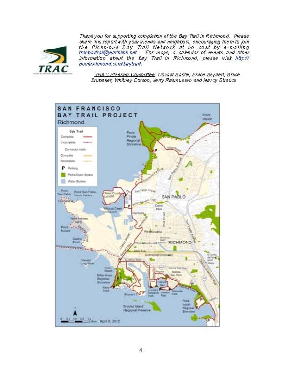
Richmond has 31 miles of shoreline trail, but another 11 miles of shoreline without trails.
To enhance habitat for fish and wildlife, the district plans to breach a levee so Bay waters can flow back in and turn 23 acres into a marsh.
The wetland project will be designed to accommodate rising sea levels due to global warming, park planners said. As some marshes are buried under water, higher lands are in position to flood and become shallow marshes.
"The project will be designed to withstand up to 50 inches of rising water levels," said Brad Olson, the park district's environmental programs manager.
Portions of Breuner Marsh trails will be built on elevated boardwalks to protect sensitive marsh areas, he said.
The complicated marsh project is expected to be completed by 2015, but some public access is expected before then, Olson said.
Contact Denis Cuff at 925-943-8267. Follow him at Twitter.com/deniscuff
Bruce Beyaert, TRAC Chair
tracbaytrail@earthlink.net
phone/fax 510-235-2835
Websites >>
TRAC: http://www.pointrichmond.com/baytrail/
City of Richmond Bay Trail: http://www.ci.richmond.ca.us/TRAC
Richmond Bay Trail Slideshows:
http://sfbaytrailinrichmond.shutterfly.com/pictures/5
Richmond Convention & Visitors Bureau:
http://www.explorerichmondca.com/baytrail.htm
Friends of the Bay Trail in Richmond, TRAC Steering Committee